Everything indicates that the heat wave we are leaving behind will be the longest since we have records. For this reason, exhausted and desperate, as the country returns to more normal temperatures for this time of year, many of us wonder if August will continue along the same lines. Weather models are beginning to draw what we can expect and, well, we have (finally!) good news.
How is August usually in Spain? The first thing we have to comment on is that, although it is true that we are going through strange times meteorologically speaking, it is not surprising that August is milder than July. In general, the average temperatures are usually lower than those of the previous month.
Not only because it is less hot (but also), but because in the second half of the month, strong storms usually begin to form that leave a lot of water or not, they tend to slow down the heat generation processes of the so-called “Iberian oven” and cool The end of summer.
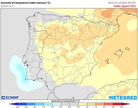
Temperatures remain above normal. Nevertheless, models like Meteored, point out that the first part of the month will continue with temperatures above normal. Up to a degree and a half above the average in the Peninsula and the Balearic Islands.
It is true that in the Canary Islands and on the coast of Galicia and the Cantabrian coast it seems that the temperatures are going to be almost normal (but, as in August the “normal” thing in many of those places is the heat, it will be hot in general). We cannot yet know if we will experience another heat wave in the interior and the Mediterranean, but we can hope that it will not be as long as the one that is ending. Luckily for us, summer is coming to an end.

There are also problems with the water. And it is that, although the month of August is expected to be drier than usual (with the few precipitations that occur concentrated in the Mediterranean basin and with a torrential nature), we can expect atmospheric instability to stir the air and prevent the heat is concentrated in the Iberian valleys. This, which will give us a break, will continue to deepen the country’s water problems (and we have been messing around with supply cuts and serious ecological problems for a long time now).
But what about the temperature of the Mediterranean? Didn’t we expect big storms? There has been some confusion on this. Yes, it’s true: the Mediterranean is very hot (it has surface temperatures similar to those of the Caribbean Sea). And yes, it is also true that this favors the creation of “cold super droplets” (or even mediterranean hurricanes).
However, the DANAs are an eminently atmospheric phenomenon: that is, if the weather conditions do not exist for there to be a cold drop, the sea may already be boiling, and there will be no cold drop. The only thing that will cause the high temperature of the Mediterranean (if it remains) is that those cold drops are more intense.
What will August be like? For now, as you can see, we only have predictions and concerns. But for now the scenario is bittersweet. ‘Sweet’ because it’s time for the temperatures to give us a break. ‘Sour’ because everything seems to indicate that the trends continue and the country’s structural problems are not on the way to being solved. At least not them alone.
Image | Gonzalez German


![[Img #74662]](https://thelatestnews.world/wp-content/uploads/2024/12/Organisms-with-the-shortest-life-150x150.jpg)


![[Img #74662]](https://thelatestnews.world/wp-content/uploads/2024/12/Organisms-with-the-shortest-life-300x200.jpg)


Add Comment