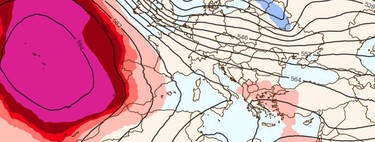
While the Canary Islands pass some pretty complicated moments Due to Dorothea’s impact, absolute stability reigns in the rest of the country. And that means something “unexpected”: heat.
Yes, heat. Just as it sounds. The first days of the week they will be marked due to a very considerable rise in temperatures that will put the thermometers of the Basque Country or Cantabria at 20 degrees and those of Murcia at 25.
What can we expect? Basically, a very considerable rise in temperature until Thursday of this week. The models indicate that the frosts are going to retreat and the coldest areas (the northern inland areas) will easily exceed 10 degrees.
Yes, the nights they will still be coldthermal inversions and widespread fog in many areas of the country. That is to say, we are going to experience some days of strong thermal fluctuations: there will be nights in the Pyrenees at -10 degrees. All this before on Friday, a cold front enters the peninsula and knocks down temperatures again (produce rain and some snow).
Should these temperatures surprise us? They may seem very high temperatures. After all, the predictions assume that Alicante, Murcia and Valencia will easily exceed 23 degrees. What’s more, everything seems to indicate (as we say) that the Cantabrian Sea is going to be above 20. These are temperatures that we would hardly associate with the Christmas period.
But perhaps the problem lies with us and our perceptions. The reality is that they are not so different from what we have become accustomed to in recent Decembers. We must not forget that 2021 closed with temperatures of up to 25 degrees in places such as the Bilbao airport; nor that we spent Christmas 2022 almost in short sleeves with “values within the 95% percentile: that is, temperatures could occur in the range of the 5% highest temperatures in the record for the date.”
In mid-December of last year the thermometers reached 28.8 degrees in Malaga, 27.7 in Murcia and 27.5 in Valencia. In perspective, this brief spike in temperatures seems ‘almost’ normal.
What do we know about the rest of the month? Although it may surprise us, these data fit the script that AEMET presented a few weeks ago. According to their general models, the week from the 16th to the 22nd was going to be warmer than normal for the date.
The interesting thing is that, according to these models, the next two weeks they were going to be colder. Much colder, in fact, in some areas of the north and the Pyrenees.
The uncertainties are still enormous, as is evident. But the ECMWF data is beginning to look like a Christmas extremely stable and that means a Christmas without precipitation. Something that, although it may sound very good, puts us back facing the ghost of drought.
Image | Tropical Tidbits (via Àlex Van der Laan)
In Xataka | For years, scientists have been trying to understand why droughts have such different impacts. We begin to have the key


![[Img #74675]](https://thelatestnews.world/wp-content/uploads/2024/12/They-discover-a-new-class-of-X-ray-sources-in-the-150x150.jpg)


![[Img #74675]](https://thelatestnews.world/wp-content/uploads/2024/12/They-discover-a-new-class-of-X-ray-sources-in-the-300x200.jpg)

Add Comment