


MADRID 18 Oct. () –
Scientists on NASA’s DAVINCI mission, which will explore Venus in the early 2030s, are preparing research using modern analysis techniques to study data from previous missions to the planet decades ago, the agency said. space. The mission will feature a flyby spacecraft and a descent probe and will focus on a mountainous region called Alpha Regio, a possible ancient continent.
DAVINCI will be the “first” mission to capture images of this area, explore it in detail and map its topography. In this way, it will take photographs of the terrain once it descends below the planet’s clouds, starting at an altitude of approximately 40 kilometers. Despite the distance, NASA has noted that these images will appear blurry because gases in the atmosphere scatter light, as does the surface.
To try to solve the problem, experts have reanalyzed data from old images of the planet with a new artificial intelligence technique that can fine-tune the images and use them to calculate three-dimensional topographic maps. Ultimately, this will help the team optimize DAVINCI images and maps of the region’s mountains. These enhanced images will give scientists the most detailed view ever seen — up to a resolution of nearly 1 meter, per pixel — which NASA says will likely allow them to detect small features on Venus such as rocks, rivers and ravines for the first time. in history.
The planet’s terrain is known as a ’tile’ for its similar appearance to Earth’s rugged mountains, although it is more irregular and disordered. The ’tiles’, so called because they resemble a geometric parquet pattern, have only been found on Venus. By analyzing the surface texture and rock types at Alpha Regio, scientists hope to determine whether the Venusian tiles formed through the same processes that create mountains and certain volcanoes on Earth.
THE GOAL IS TO USE THE Descent OF THE PROBE MORE EFFECTIVELY
Additionally, by studying data from past missions, scientists want to more effectively use the probe’s descent time to gather new information that can help answer long-standing questions about the evolutionary path of Venus and why it became drastically deviated from that of the Earth.
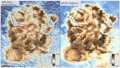
Thus, the mission team has sought more details in the maps prepared with the Magallanes space probe, which mapped the topography of the area from the orbit of Venus with radar and altimetry images between 1990 and 1994. In this framework, scientists They applied new techniques to analyze radar altimeter data. They then supplemented this data with radar images taken three times from the former Arecibo Observatory in Puerto Rico and used computer vision models to examine the data and fill in information gaps at new scales (less than 0.6 miles). or 1 kilometer).
Thanks to all this, the experts managed to improve the resolution of the Alpha Regio maps by ten times, predicted new geological patterns on the surface and raised questions about how these patterns could have formed in the mountains in the area.


![[Img #74674]](https://thelatestnews.world/wp-content/uploads/2024/12/Santiago-Ramon-y-Cajal-The-promoter-of-modern-neuroscience-300x200.jpg)
Add Comment