


3 Feb. () –
The settlement process of the entire continent of Sahul – the combined megacontinent that linked Australia with New Guinea when sea levels were much lower than today – lasted 10,000 years.
Sophisticated new models combined recent improvements in demography and orientation models based on geographic inferences to show the magnitude of the challenges facing Aboriginal ancestors. in their mass migration across the supercontinent more than 60,000 years ago.
It is likely that the ancestors of the Aboriginal people first entered the continent some 75,000-50,000 years old from what is now the island of Timorfollowed by later migrations through the western regions of New Guinea.
According to the new research, this pattern led to rapid expansion both south towards the Great Australian Bight and north from the Kimberley region to colonize all parts of New Guinea and later the southwest and southeast Australia.
The research was led by the ARC (Australian Research Council) Center of Excellence for Australian Biodiversity and Heritage (CABAH) and involved international experts from Australia and the United States to investigate the most likely pathways. and the time needed to reach population sizes capable of withstanding the rigors of their new environment.
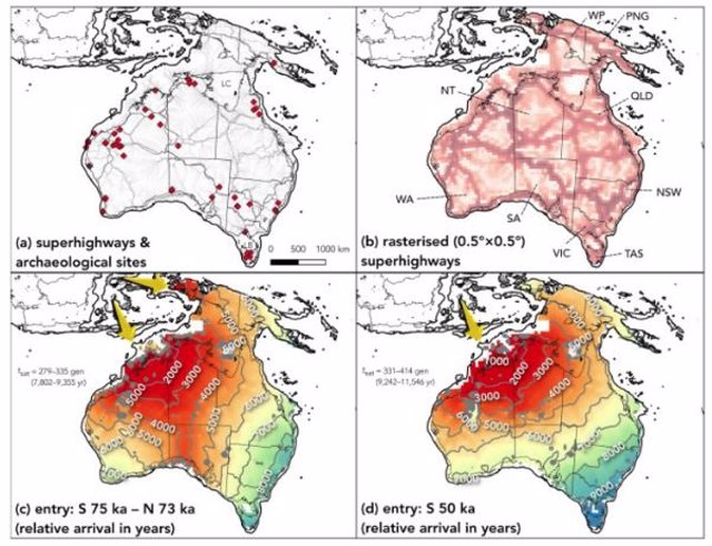
By combining two existing models that predicted the routes they took – the “superhighways” – and the demographic structure of these early populations, the researchers were able to more accurately estimate the time required for continental saturation. The new research has just been published in the international journal Quaternary Science Reviews.
Based on detailed reconstructions of the ancient continent’s topography and climate models of the past, the researchers developed a virtual continent and programmed the populations. to survive and successfully navigate their new territory.
Navigating along landscape features, such as mountains and hills, and knowing where to find water led to successful navigation strategies. The first inhabitants of Australia did not take long to pass on their cultural knowledge to the following generations, which facilitated the settlement of the entire continent.
However, the challenges posed by Sahul’s topography slowed the pace of migration. Previous models did not take into account the topographic limitations that this sophisticated model does have, which allows a more realistic estimate of the population of the continent. This new work also explains how slowly indigenous ancestors reached Tasmania, which was only possible when the waters of Bass Strait receded, a finding that was only possible by combining the results of these models.
The study’s lead author, Corey Bradshaw, the Matthew Flinders Professor of Global Ecology at Flinders University and lead on the topic of CABAH models, says that together, these combined models provide a better understanding of the archaeological and genetic data that explain the large migrations of the indigenous peoples of Sahul.


![[Img #73262]](https://thelatestnews.world/wp-content/uploads/2024/07/The-era-of-artificial-intelligence-in-digital-marketing-in-Spain-300x200.jpg)