

![[Img #74661]](https://thelatestnews.world/wp-content/uploads/2024/12/The-power-of-ultrasound-150x150.jpg)


Aug 2 (Portaltic/EP) –
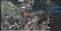
The Cabildo of Gran Canaria has implemented a 3D simulator of forest fires by scanner that uses geographic information systems (GIS) control forest fires.
Currently this region, like Galicia, Castilla y León, Asturias, Navarra or Extremadura, is on alert for extreme risk due to high temperatures and is positioned as one of the most affected by these natural disasters.
To mitigate its effects and as part of its initiative ALERTGREAT, the Cabildo de Gran Canaria has implemented a 3D simulator of forest fires that makes use of the GIS system to analyze data in real time.
Thanks to this, you can foresee how the fire will behave, what areas it will reach, how it will move and when the fire may start, in order to act accordingly.
This simulator has been developed by Tecnosylva with the Esri ArcGIS technology, company dedicated to ‘location intelligence’, which allows the information collected from a spatial point of view to be analyzed, to capture it on a map, study it and make agile decisions to control the fire.
This system allows fire risks to be calculated daily through automatic simulations of possible scenarios for forest fires.
This information can not only be seen in the 3D simulator, but also can be spread in other formats (geographic ‘datasets’, tables, etc.) to carry out multiple evaluations of the scenarios based on different parameters.
As Esri recalls in a press release sent to Europa Press, since January 1, 2022, the simulator has performed 69,4445 automatic simulations, with a total of 556,540 simulated hours. The results have shown 4,798,202 hectares burned and 58,549 impacted buildings.
![[Img #74661]](https://thelatestnews.world/wp-content/uploads/2024/12/The-power-of-ultrasound-300x200.jpg)


Add Comment