


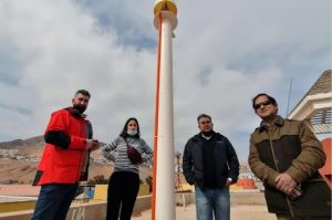
Enzo Borroni Ricardi, USACH Communications.– A collaboration agreement between the Department of Geospatial and Environmental Engineering of the Usach and the Department of Geometry and Geomatics of the Faculty of Engineering of the University of Antofagasta, allowed the installation in this last House of Studies of a GNSS satellite base station that It opens up the possibility of registering the movement of tectonic plates with millimeter precision and thereby better understanding phenomena such as earthquakes or tsunamis.
The equipment sends positioning information to an international network of satellites and in this way is capable of detecting minimal displacements of the earth’s crust, data that is shared in real time with the IGS global network and the SIRGAS continental subnetwork to recreate with great accuracy the complete and up-to-date shape of the Earth.
Said accurate and updated information, which includes the temporal component of the reference frames in highly seismic environments, will allow scientific studies to contribute to the knowledge of the country’s geodynamics with research.
Dr. José Antonio Tarrío, director of the Usach Department of Geospatial and Environmental Engineering and president of SIRGAS Working Group 1, explained that the geodetic station, using GNSS technology, integrates data from different positioning systems, such as GPS, Glonass, Galileo and Beidou, which, together, provide much more precise information than if they acted separately.
For his part, the deputy director of teaching of said Department, Dr. Marcelo Caverlotti, added that the project provides this GNSS antenna on loan for 5 years, under conditions of free access to information for the entire community, especially the scientific community for realize “processing of observations for analysis with interest in research of geodynamic phenomena such as tides, the movement of tectonic plates, earthquakes, among others, in addition to serving as a basis for detailed engineering surveys”.
Role of the Usach
Professor Carvelotti indicated that our University not only fulfills the fundamental role in the training of top-level professionals who effectively help the country’s development, but also supports the different state agencies and institutions to better develop its functions.
“We have contributed from technical and scientific knowledge in the continuous improvement of its processes, in this case academic and research from a friend University with origins in our beloved UTE”, he added.
On the other hand, the researcher specified that “contributing to the densification of our geodetic frame of reference is essential so that knowledge can be transmitted at the highest level in teaching, in this case in the area of Geodesy, both in undergraduate and graduate studies. postgraduate”.
“Furthermore, it allows us to promote links at the national level such as scientific cooperation between universities and also contribute in extension, technology transfer, in this case through the contribution in applied geodesy, and of course in research”, Dr. Caverlotti emphasized. .
Finally, he stressed that the ties with the University of Antofagasta are current and robust. “We are working with Dr. Gabriel Álvarez Ávalos, who develops the area of tsunamis, but also with other Geodesy specialists, as is the case with Magister Patricio Alcorta, so new scientific studies can surely be generated in these areas within the near future”, concluded Caverlotti.


![[Img #74662]](https://thelatestnews.world/wp-content/uploads/2024/12/Organisms-with-the-shortest-life-300x200.jpg)
Add Comment