


The end of last week and the beginning of this one have been characterized by stable and warm weather. However, this “spring” it ends tomorrow with the arrival of cold, especially from Thursday, and rains that could turn into snow in various parts of the country. This abrupt change could have a curious effect: rains of mud.
Mud showers. The return of winter weather will bring with it some standard phenomena such as falling temperatures, rain and snow. However, it could also bring with it a somewhat less frequent phenomenon, that of mud rainalso sometimes known by a more melodramatic name: “rain of blood”.
Mud rain is the mere combination of suspended dust and rainwater. Last week the haze was one of the protagonists in the weather. Now, the arrival of the rains can drag the dust that was still in the atmosphere, creating this phenomenon and taking the haze with it.
Although the rain of mud is a more common phenomenon on the Mediterranean slope, but this week we could see it in the west and northwest of the peninsula, in places like Extremadura and Galicia; but also in Asturias, Cantabria, and Castilla y León.
Drop in temperatures. The cold will be despite this the great protagonist of this week. Temperatures will drop slightly on Wednesday to plummet on Thursday, especially in the northern half of the peninsula.
In Burgos, for example, a drop of 15 degrees is expected on Thursday compared to the temperature observed on Monday. Even cities near the coast such as Bilbao and Oviedo will see significant drops of 13º and 12º respectively.
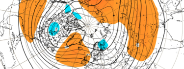
A week of instability. Not all rainfall will be accompanied by mud. Some will come in the form of snow. Rainfall is expected throughout the northern half of the peninsula. In combination with the rest of temperatures, it is expected that the snow will also take center stage especially from Thursday.
AEMET has issued yellow notices due to snowfall throughout the northern half of the peninsula, from Lugo to Girona and reaching the Serranía de Cuenca, with orange warnings on Thursday in Asturias, Cantabria and Vall d’Aran.
In suspense still by the vortex.
This drop in temperatures could be even greater if the break of the polar vortex is confirmed. A phenomenon that has been capturing the attention of meteorologists for a few months. The rupture of the vortex could bring with it a wave of storms with effects similar to those we will experience this week, although more aggravated.
For now, yes, it seems that the vortex is holding, so we have at least a few days of “conventional” winter ahead. We will have to wait to see how many.
Image | Probability of precipitation in the form of snow on Thursday 23 and effects of calim. ECMWF/javygo