
![[Img #74144]](https://thelatestnews.world/wp-content/uploads/2024/10/The-largest-molecules-found-in-space-150x150.jpg)


September 30 () –
Mount Everest is between 15 and 50 meters higher than it would otherwise be due to uplift caused by erosion of a nearby river gorge, and continues to grow because of it.
This is the conclusion of a new study carried out by researchers at University College London and published in ‘Nature Geoscience’.
Research has found that the erosion of a river network about 75 kilometers from Mount Everest It is excavating a large gorge. The loss of this land mass is causing the mountain to rise up to 2 millimeters a year and has already increased its height between 15 and 50 meters in the last 89,000 years.
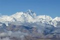
Mount Everest, also known as Chomolungma in Tibetan or Sagarmatha in Nepali, is the highest mountain on Earth with 8,849 meters high and surpasses the next highest peak in the Himalayas by about 250 meters. Everest is considered to be an anomalously high mountain for the range, as the next three highest peaks (K2, Kangchenjunga and Lhotse) only differ from each other by about 120 meters.
A significant part of this anomaly can be explained by a lifting force caused by the pressure exerted from beneath the earth’s crust after a nearby river eroded a considerable amount of rock and soil. It is an effect called isostatic rebound, in which a section of the Earth’s crust that is losing mass flexes and “floats” upward because the intense pressure of the liquid mantle below is greater than the downward force of gravity after the mass loss. It is a gradual process, usually only a few millimeters a year, but over geological periods can make a significant difference to the Earth’s surface.
The researchers found that, due to this process, Mount Everest grew between 15 and 50 meters in the last 89,000 years, since the nearby Arun River merged with the adjacent Kosi River network. Co-author and PhD student Adam Smith (UCL Earth Sciences) said: “Mount Everest is an extraordinary mountain, full of myths and legends, and it continues to grow. Our research shows that, as the nearby river system deepens , the loss of material makes the mountain rise even higher.”
Today, the Arun River runs east of Mount Everest and is joined downstream by the larger river system of the Kosi River. Over the millennia, the Arun has carved a considerable gorge along its banks, carrying away billions of tons of soil and sediment.
Co-author Dr Jin-Gen Dai from the China University of Geosciences argues: “There is an interesting river system in the Everest region. The Arun River, upstream, flows east at high altitude with a flat valley. .It then turns abruptly south as the Kosi River, dropping in elevation and becoming steeper. This unique topography, indicative of an unstable state, is likely related to Everest’s extreme height.“.
The upheaval is not limited to Mount Everest, but affects neighboring peaks such as Lhotse and Makalu, the fourth and fifth highest peaks in the world, respectively. Isostatic rebound increases the height of these peaks by a similar amount to that of Everest, although Makalu, located closer to the Arun River, would experience a slightly greater rate of uplift.
Co-author Dr Matthew Fox (UCL Earth Sciences) adds: “Mount Everest and its neighboring peaks are growing because isostatic rebound lifts them faster than erosion wears them down. We can see that they are growing at a rate of about two millimeters a year using GPS instruments and now we have a better understanding of what drives it.”
By looking at erosion rates of the Arun, Kosi and other rivers in the region, researchers were able to determine that about 89,000 years ago the Arun River joined and merged with the Kosi river network, a process called drainage piracy. In doing so, more water was channeled through the Kosi River, increasing its erosive power and taking with it more soil and sediment from the landscape. Dragging more soil triggered an increase in the rate of uplift, which caused the mountain peaks to rise higher and higher.
Lead author Dr Xu Han of China University of Geosciences, who carried out the work during a China Scholarship Council research visit to UCL, concludes: “Mount Everest’s change in height really highlights the natural dynamics of the Earth’s surface. The interaction between the erosion of the Arun River and the upward pressure of the Earth’s mantle gives Mount Everest a boost, pushing it higher than it would otherwise reach.”
![[Img #74144]](https://thelatestnews.world/wp-content/uploads/2024/10/The-largest-molecules-found-in-space-300x200.jpg)

Add Comment