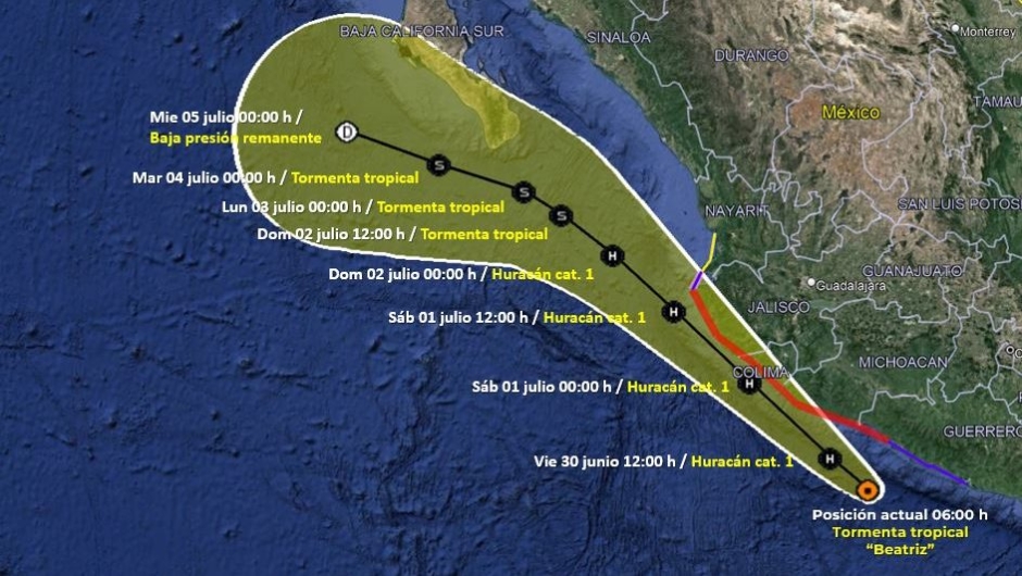
( Spanish) — Tropical storm Beatriz, formed on Thursday June 29 off the coast of western Mexico, in the Pacific Ocean, is moving west-northwest at 20 km/h and will bring torrential rains to the states of Jalisco, Colima, Michoacán and Guerrero and intense rains to Oaxaca and Chiapas, according to the National Meteorological Service of Mexico.
He US National Hurricane Center (NHC) projected rapid intensification as it moves northwestward, paralleling the coast.
The Mexican states that Beatriz will affect
According to the most recent warning of the National Meteorological Service (SMN) of Mexico, Beatriz continues to intensify its winds as it now moves south of Guerrero and Michoacán.
“Its cloud bands will cause heavy to occasional torrential rains in the west, center, south, and southeast of the country, including the Valley of Mexico. These rains could increase the levels of rivers and streams, as well as cause landslides and floods in those regions.” says the SMN.
The authorities forecast “strong gusts of wind and high waves” on the coasts of Jalisco, Colima, Michoacán and Guerrero.
The cloudy bands will cause punctual torrential rains in Jalisco, Colima, Michoacán and Guerrero, precipitations of 150 to 250 mm.
In turn, there will be intense rains, 75 to 150 mm, in Oaxaca and Chiapas, say the SMN.
It will also bring very strong punctual rains, 50 to 75 mm, in Guanajuato, the State of Mexico, Morelos and Puebla, as well as strong punctual rains in Mexico City, which are 25 to 50 mm rainfall.
Beatrice’s prognosis
According to the NHC in its report for this fridayTropical Storm Beatriz is expected to move northwestward for the next few days, “with a gradual decrease in forward speed occurring over the weekend.”
The NHC is forecasting rapid strengthening and Beatriz is likely to become a hurricane later this Friday and continue at that intensity as the center moves near or over the coast of Mexico.
On Thursday, the general coordinator of the National Meteorological Service of Mexico, Alejandra Margarita Méndez Girón, explained at a press conference that Beatriz will continue her movement this Thursday and Friday over the warm waters of the Pacific Ocean, “which could favor its gradual intensification into a hurricane registering winds from 119 to 153 km/h, approximately 25 km from the coasts of Michoacán, Colima and Jalisco”. On Saturday, the storm will move “approximately 25 km from the coasts of Colima and Jalisco, in whose coastal municipalities it could cause winds of up to 120 km/h.”
In its report on Thursday night, the SMN indicated that there is a prevention zone for hurricane effects from Zihuatanejo, Guerrero, to Playa Pérula, in the state of Jalisco. Also, surveillance zone for hurricane effects from Playa Pérula to Cabo Corrientes, Jalisco.
In turn, there is a prevention zone for the effects of tropical storms from Zihuatanejo to Punta Maldonado, Guerrero, and there is a surveillance zone for the effects of tropical storms from Cabo Corrientes, Jalisco, to Punta Mita, in the state of Nayarit.
hurricane season
Beatriz is the second tropical system that has been recorded in the Pacific in the current season, after Hurricane Adrián.
For this cyclone season, the authorities estimated from 16 to 22 named cyclones for the Pacific (Adrián being the first), and from 10 to 16 named cyclones for the Atlantic (where to date there are three).
Of those 16 to 22 named cyclones in the Pacific, there are forecast to be four to six Category 1 or 2 hurricanes, making Adrian also the first such hurricane in the 2023 forecast.
With information from Uriel Blanco, Sebastián Jiménez, Fidel Gutiérrez and Taylor Ward


![[Img #74664]](https://thelatestnews.world/wp-content/uploads/2024/12/James-Watson-The-controversial-genius-behind-the-double-helix-150x150.jpg)


