


![[Img #74674]](https://thelatestnews.world/wp-content/uploads/2024/12/Santiago-Ramon-y-Cajal-The-promoter-of-modern-neuroscience-150x150.jpg)


Doñana no longer seems even remotely what it once was. This natural spot that gives life to different aquatic and terrestrial ecosystems and that one day it was declared a World Heritage Site by Unesco, it’s drying up, literally. In recent decades, something has been altering its landscape. The aquifer is currently below 30% of its capacity, the result of consecutive years of low rainfall, which have had a great impact on the biodiversity of the area.
But it is not only the drought.
Precisely, the groundwater that makes the wetland nourished, also is being used for other uses outside the national park. The agriculture and tourism beyond the borders of the park are aggravating the low water supply, necessary for fauna (animals such as the Iberian lynx or the imperial eagle are in danger of extinction), and plants. And, at the same time, it has caused a constant dispute between farmers in the area.
In recent decades, farmers near the wetland have shifted from cultivating drought-adapted crops, such as olives and cereals, to more water-intensive crops, like strawberries. On the other hand, the area also faces an overexploitation of the aquifer and hundreds of illegal wells in limbo.
on Magnet we have talked about the phenomenon and we have collected some Copernicus satellite photos in the past to compare how the drought and bad policies are taking their toll on the area, as well as the metamorphosis that you have experienced. Today, however, we bring another irrefutable proof from the hands of NASA of how the human being (and not so much the climate) is completely finishing off this redoubt of nature.

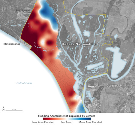
As we can see on the map, the low water level in a large area of Doñana and the anomalies in recent years cannot be explained solely by the weather. This studio has used satellite data from more than three decades to understand how human demands over the aquifer have affected the ponds.
For this, the scientists of the Biological Station of Doñana used Landsat images to quantify the range and the duration of flooding in 316 ponds between 1985 and 2018, adding temperature, rainfall and land use data from that time to illustrate how much of the problem is due to climatic factors and how much to humans.

The conclusion is quite tragic: the use of groundwater by others caused most of the ponds analyzed to fill less frequently and, in some cases, to dry up completely. In fact, the most noticeable impacts appear right where the water is pumped. For example, the tourist city of Matalascañas built since 1970 along the coast, it takes advantage of groundwater to water a golf course. And on the western fringe of the park, greenhouses growing strawberries and other berry crops draw water from the aquifer for irrigation.
Only eight ponds in the north of the park have continued to fill with water. Even more than expected considering the dry and little rainy climate. In this case, the authors believe it is due to stream restoration and eucalyptus removal in the early 2000s.

Comparison of the Doñana Park between 2011 and 2022.
As we explained in this other articleIntensive agriculture has been carried out around Doñana for the last decade. In this case, that has involved the proliferation of illegal wells in the area, to which the institutions have turned their backs in many ways. Many of these wells They are not legal or declared and camouflage inside greenhouses. The problem has been on the table for a long time, but it has been this 2023 that has brought us back to drama for a controversial bill (made to further exploit its hydrography).
The European Commission has studied the case and notified the Government a few months ago of the consequences and possible sanctions to which Spain could be exposed. Already the European Court of Justice condemned the alteration of habitats protected areas caused by groundwater extraction. And, both environmental organizations and the EU consider that this situation is unsustainable in the long term.
Map and images: Earth Observatory / NASA
In Xataka | Spain has a huge problem with the water in its reservoirs, but an even bigger one with its aquifers
![[Img #74674]](https://thelatestnews.world/wp-content/uploads/2024/12/Santiago-Ramon-y-Cajal-The-promoter-of-modern-neuroscience-300x200.jpg)