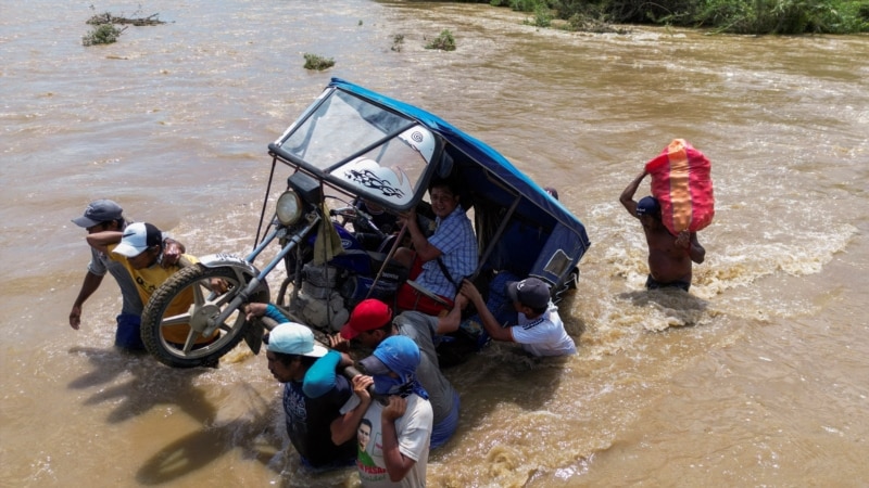
Peru is currently facing intense rains, flooding of cities and highways, and river overflows due to the surprise appearance of Cyclone Yaku on its coasts.
According to the latest report from the National Emergency Operations Center (COEN), the meteor has caused 58 deaths, 12,110 homeless and 45,181 affected. In addition, there are 57 injured and eight missing.
Regions of northern Peru such as Tumbes, Lambayeque, Cajamarca, La Libertad and Piura announced the delay in the return of school classes. On the other hand, Lima also suspended, at least a week, that children can attend schools due to the rains that are already registered in the capital.
“Yaku has come after 40 years and has devastated the same as always, the poor, the vulnerable population. Each campaign, each mayor, each governor offers and offers and offers. We are putting our feet on the ground so that when another cyclone comes, it will find us provided with a solution,” said Peruvian President Dina Boluarte from Piura.
However, a great debate has arisen about the origin of Cyclone Yaku. An expert consulted by the Voice of America in Lima details us about it.
What is Cyclone Yaku?
Patricio Valderrama, former head of the National Meteorology and Hydrology Service of Peru (Senamhi), explained that Yaku is the word for water in Quechua and “that the term cyclone does not indicate force, power and danger, but rather movement.”
“A cyclone is when an air mass moves clockwise from right to left,” Valderrama said.
In his opinion, Cyclone Yaku is “an air mass that is in synchronous movement and has extremely low winds at 18 and 20 kilometers per hour.”
“He is really small. For this reason, there is a very strong controversy as to whether this phenomenon should be called a cyclone, because if we go strictly to the concepts it does not fit ”, he adds.
Senamhi has described this phenomenon as an “unorganized tropical cyclone”.
When would it have originated and its duration?
According to Valderrama, who owns a private monitoring team, Yaku began to take shape in mid-January. “February was the month in which the Peruvian sea warmed” which ended up causing the weather phenomenon and torrential rains that we see this month.
“In 2017 we had a warming of the sea due to the phenomenon of the Coastal Child. Without any cyclone in sight, ravines were activated in Lima and Piura, Tumbes, Chiclayo were flooded, ”he recalled.
The Peruvian sea has been extremely cold due to the La Niña phenomenon in the last four years. “It was colder than normal, that dries up the coast and doesn’t cause it to rain,” Valderrama said.
According to data from Senamhi, between January and February of this year there was a temperature of 28 degrees Celsius in the Peruvian sea.
Valderrama estimates that Cyclone Yaku would lose intensity in these days – between March 13 and 15 – on the Peruvian coast, but in the north it will continue with some intensity. “On March 23, 24 or 25, the rains will start to subside.”
Could it become a hurricane or typhoon?
The expert rules out the possibility that the Yaku cyclone could mutate.
“He could not convert because he does not have the necessary strength or the conditions. In the southern hemisphere, all air and water masses tend to move to the left. Everything indicates that Yaku is going to die because he is going to lose a lot of energy ”, he maintains.
Valderrama added that if the cyclone were still alive it would be offshore. “It is not possible for it to come close to the coasts of Peru due to the choriolysis effect and the rotation of the earth,” he notes.
“Yaku is standing at the height of the cities of Piura and Lambayeque. It’s not like Hurricanes Katrina and Mitchell,” she said. On the other hand, he emphasized that the effect in Lima, the Peruvian capital, will be minimal and will only have the typical summer rains.
Valderrama mentions that this event will not have a similar effect compared to what happened between 1982-1983 and 1997-1998 with the El Niño phenomenon.
Possible consequences
The expert assures that after the change of season the Peruvian sea will be warm. For this reason, he indicated that the corresponding authorities should adopt a plan for the next nine months remaining in 2023 given the possibility that a similar phenomenon such as Cyclone Yaku appears next summer.
“The lack of preparation in Peru is scandalous. In 2017, El Niño Costero caught us off guard due to the lack of monitoring. It seems that we are more effective in responding to the emergency than in preventing this type of natural disaster, ”he explained.
Valderrama maintains that the government and municipalities should work on infrastructure, canals and drainage so that the cities are not affected. He added that bridges, roads, medical posts, police headquarters or schools will be left in very poor condition.
“We return to exhibit in the same cities and families that lost everything six years ago and will do it again. That’s not fair,” he finished.
The Peruvian coast is in a red or high danger level. Senamhi and the Civil Defense of Peru recommended that people reschedule activities and protect assets in areas exposed to heavy rains.
In addition, they urged the authorities to monitor the rivers due to possible overflows that could affect homes and transportation routes in the cities.
Connect with the Voice of America! Subscribe to our channel Youtube and activate notifications, or follow us on social networks: Facebook, Twitter and Instagram.



![[Img #74661]](https://thelatestnews.world/wp-content/uploads/2024/12/The-power-of-ultrasound-150x150.jpg)


