


The eye of Tropical Storm Karl was about to make landfall on the southern coast of the Gulf of Mexico on Friday afternoon, in a stretch that is prone to flooding.
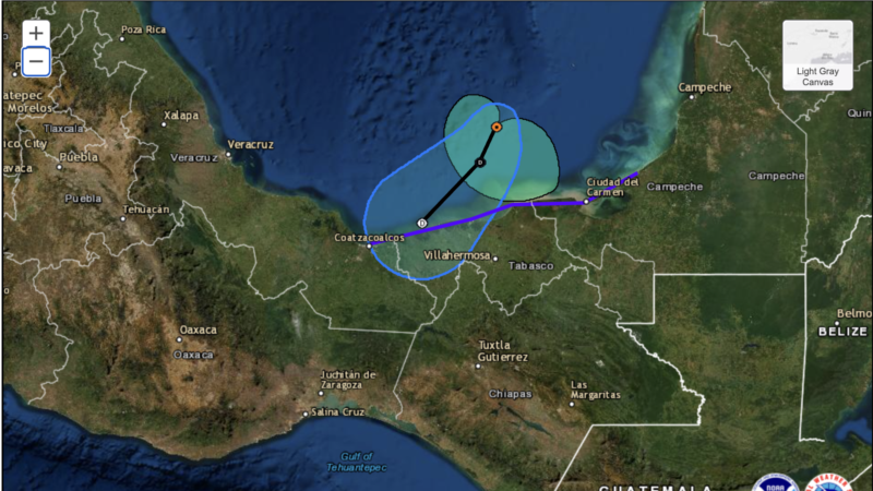
According to the National Hurricane Center (NHC), in its 4 pm CDT report, Karl was 155 km from Ciudad del Carmen, Mexico, with maximum sustained winds of 65 km/h.
According to meteorological authorities, the center of Karl will reach the coast of southern Mexico between Friday night and Saturday morning.
“The forecast rains could generate landslides, increase in river and stream levels, overflows and flooding in low-lying areas,” Mexico’s National Water Commission reported in a statement.
Karl increased its maximum sustained winds to 75 kilometers per hour on Friday morning, the NHC reported.
The Mexican government discontinued the tropical storm watch west of Coatzacoalcos to Alvarado. However, it continues in effect for the area from Coatzacoalcos to Sabancuy.
Tropical storm-force winds of at least 75 kilometers per hour extended up to 95 kilometers from the center of the meteor.
The system is expected to weaken after landfall, and dissipate over the coast by Saturday night.
Karl could dump 8 to 18 centimeters of rain in some parts of Veracruz and Tabasco, as well as in the states of Chiapas and Oaxaca until Sunday morning, the Hurricane Center said, adding that in some isolated points they could register up to 30 centimeters.
“These rains can produce flash flooding, as well as landslides in highlands,” the advisory said.
Connect with the Voice of America! Subscribe to our channel Youtube and turn on notifications, or follow us on social media: Facebook, Twitter and Instagram.