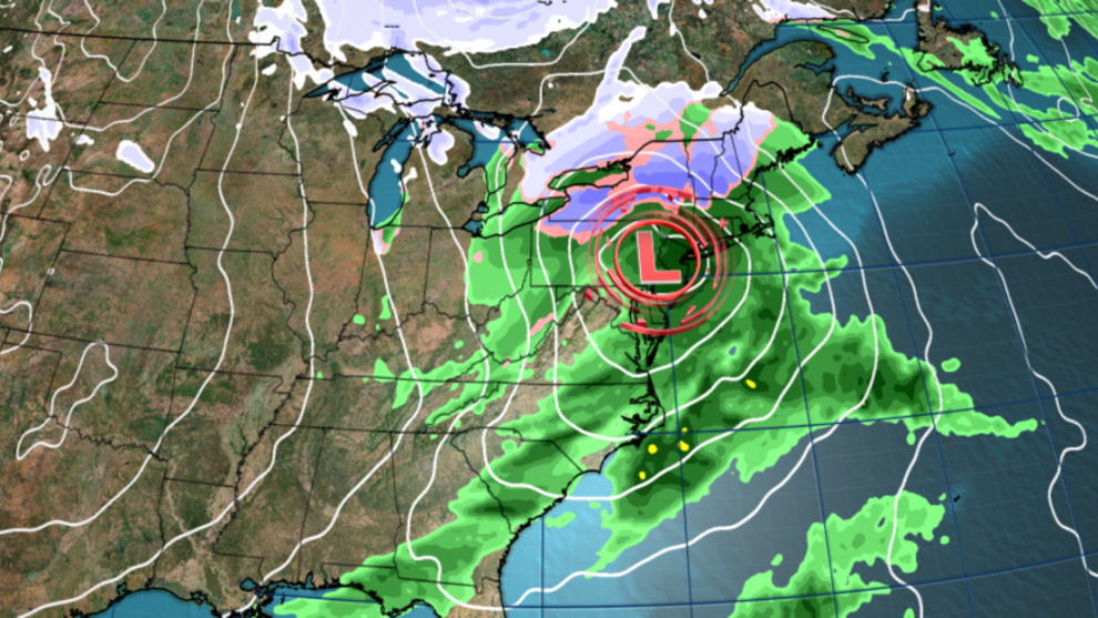
() – A storm and the first hit of winter cold will combine to cause Thanksgiving travel headaches in the eastern half of the United States, as Mother Nature delivers a mix of disorganized weather.
The storm will move through parts of the Midwest and South on Wednesday night and spread across the east on Thanksgiving Day. At the same time, the frigid air will enter the United States as if they were buyers clamoring for the deals of the Black Friday.
The exact path of the storm is still unclear and will determine which areas will receive snow over the holiday and which will end up with a wet, depressing mess. But there are two scenarios at play and in each one there will be a storm that will disrupt last-minute travelers.
In the first scenario, a storm would develop over the Plains on Wednesday and strengthen as it heads east. It would become quite a force Wednesday night as rain spread from the Midwest southward.
It would turn northeast once it reaches the Appalachian Mountains and follow its spine on Thursday, taking advantage of the cold Canadian air before heading directly toward the New England coast overnight.
This would cause a round of heavy, wet snow in the high interior areas of the Northeast on Thursday, while rain would drench the lower elevations.
Wind speeds would also increase on Thursday in the east, with possible widespread gusts of up to 48 km/h. Stronger gusts are possible in areas closer to the coast, especially from the Carolinas to southern New England.
Strong winds could disrupt air and road travel for last-minute travelers on Thanksgiving Day. The combination of wet weather and strong winds could also down trees or power lines.
The storm was expected to reach northern Maine on Friday morning and leave the U.S. shortly thereafter. This would lead to mostly dry, but still windy weather in the east on Friday and into the weekend.
Another possible scenario would see the heavier rain and risk of wet snow move largely out of the Northeast and instead create a much wetter Thanksgiving for the mid-Atlantic.
In this scenario, the storm would develop late Wednesday night around the Mississippi or Tennessee valleys. It would then move slowly across the mid-Atlantic overnight on Thursday and reach the Atlantic on Friday morning.
This would bring more rain to the Southeast and mid-Atlantic on Thursday, while limiting the chances of heavy rain and snow accumulation in the Northeast.

But how far offshore the storm is once it reaches the Atlantic on Friday will affect post-holiday travel.
A mix of rain and snow could develop in the Northeast and slowly approach the coast if the storm skirts the coast and heads toward New England. This could lead to disastrous conditions Friday at Boston-area airports and for people traveling along the Interstate 95 corridor.
Wet weather would be minimal for these areas if the storm moves away from the coast on Friday.
A widespread blast of cold Canadian air will reach much of the US, regardless of the final track of the late-week storm.
Cold air will begin to seep into northern states early this week, before a major winter wind becomes widespread on Thursday.
Chicago could see 1.6°C on Thanksgiving Day, a temperature more appropriate for late December. Some parts of North Dakota will feel a more January wind chill.
Millions of people from coast to coast will suffer from the cold on Friday.
High temperatures as far south as the Gulf Coast will likely be 5.5 degrees or more below normal and may not reach 15.5°C in some places.
Many locations in the central and eastern US will experience their coldest conditions so far this season over the weekend.
Philadelphia hasn’t recorded a high temperature of -1.1°C since February, but it could get close on both Saturday and Sunday. The same can be said for New York City.
The frigid air that will blow in later this week will also activate the Great Lakes lake effect snow machine. Cold Canadian air rushing over the lakes, which reached record temperatures, will set the stage for lake effect snow that could persist into next week in some areas.
Cold air will linger across much of the east as the calendar turns to December and could last into the first week of the new month, according to forecasts from the Climate Prediction Center.


Add Comment