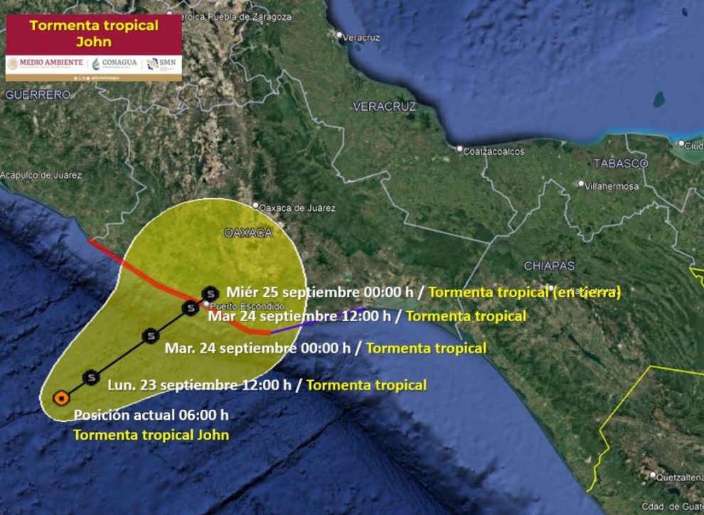
( Spanish) – Tropical Storm John It was formed in the last minutes of Sunday Central Mexico time (early Monday morning in Miami) against Oaxaca coastsaccording to the National Meteorological Service (SMN) of Mexico and the National Hurricane Center (NHC) of the United States.
John became the tenth named storm of the 2024 Pacific tropical cyclone season. Of these cyclones, two have become hurricanes (Carlotta and Gilma), points out the SMN.
According to the Update at 6:00 am local time According to the National Hurricane Center (8:00 am Miami time), Tropical Storm John is strengthening as it approaches Mexico, and is already generating rain in the south and southeast of the country.
John is forecast to continue to gradually gain strength before making landfall.
The tropical cyclone is currently moving slowly, at a speed of 6 km/h, towards the north-northeast, according to the SMN.
At 6 a.m. on Monday, according to the SMN, John was located 200 km south of Punta Maldonado, Guerrero, and 250 km west-southwest of Puerto Ángel, Oaxaca.
It is expected to continue its path north-northeastward before making landfall in Oaxaca.
The SMN forecast highlights that, for the moment, John will not become a hurricane and will reach land as a tropical storm.
However, the NHC suggests staying tuned for updates because “John could get stronger than what is forecast depending on how long it stays above the water.”
At this time, John’s trajectory indicates that the tropical storm is heading towards Oaxaca and is expected to make landfall on Tuesday, September 24 around noon.
As of 6 a.m. Monday, Tropical Storm John has sustained winds of 100 km/h and gusts of 120 km/h.
John is expected to produce the following effects:
- Extraordinary rainfall (over 250 mm) in Oaxaca.
- Torrential rains (150 to 250 mm) in Guerrero and Chiapas.
- The potential for intense rainfall (75 to 150 mm) increases in areas of Veracruz.
- The potential for very heavy rainfall (50 to 75 mm) also increases in Morelos and Puebla.
- And also the potential for heavy rains (25 to 50 mm) in areas of the State of Mexico.
- Winds with gusts of 70 to 90 km/h and waves of 2 to 4 meters high are expected on the coasts of Oaxaca.
- Wind gusts of 40 to 60 km/h with waves of 1 to 3 meters high are also forecast on the coasts of Guerrero and Chiapas.
- In these cases, there is a probability of waterspout formation.
According to the public notice According to the latest from the NHC, these are the current watches and warnings for Tropical Storm John:
- Tropical storm warning from eastern Huatulco Bay to Salina Cruz, Oaxaca.
- Hurricane warning from Punta Maldonado, Guerrero, to Huatulco Bay, Oaxaca.
“A hurricane warning means that hurricane conditions are expected somewhere within the warning area, in this case within the next 24 to 36 hours. Preparations to protect life and property should be made quickly,” the NHC said.
“A tropical storm warning means that tropical storm conditions are expected somewhere within the warning area within the next 36 hours,” it added.
–With information from Gene Norman, .


Add Comment