


![[Img #74674]](https://thelatestnews.world/wp-content/uploads/2024/12/Santiago-Ramon-y-Cajal-The-promoter-of-modern-neuroscience-150x150.jpg)
Aug. 2 () –
First detailed maps of the underside of a floating ice shelf in Antarctica reveal clues about future sea level rise.
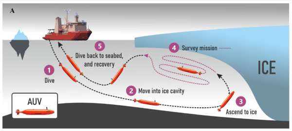
An international research team, including scientists from the University of East Anglia (UEA), deployed an unmanned submersible beneath the Dotson Ice Shelf in West Antarctica.
The underwater vehicle, “Ran,” was programmed to dive into the cavity of the 350-meter-thick ice shelf and scan the ice above it with advanced sonar. Over 27 days, the submarine traveled more than 1,000 kilometers round trip beneath the shelf, reaching 17 kilometers inside the cavity.
An ice shelf is a mass of glacial ice, fed from land by tributary glaciers, that floats at sea on an ice shelf cavity. The Dotson Ice Shelf is part of the West Antarctic Ice Sheet, and is adjacent to Thwaites Glacier, which is considered to have a potentially large impact on future sea level rise due to its size and location.
Researchers report the results of this unique study in a new paper published in the journal Science Advances.
They found some things that were expected, for example, the glacier melts faster where strong underwater currents erode its base. Using the submersible, they were able to measure the currents beneath the glacier for the first time and show why the western part of the Dotson Ice Shelf is melting so fast. They also found evidence of very high melting in vertical fractures that run through the glacier.
However, the team also saw new patterns at the base of the glacier that raise questions. The mapping showed that the base is not smooth, but instead there is an ice landscape of peaks and valleys with plateaus and formations that resemble sand dunes. The researchers hypothesize that these may have been formed by the flow of water under the influence of the Earth’s rotation.
HOW TO SEE THE BACK OF THE MOON FOR THE FIRST TIME
Lead author Anna Wahlin, Professor of Oceanography at the University of Gothenburg in Sweden, said: “We have previously used satellite data and ice cores to observe how ice shelves change over time. By lowering the submersible into the cavity, we were able to obtain high-resolution maps of the underside of the ice. It’s a bit like seeing the back of the moon for the first time.”
The expedition took place in ice drift regions in West Antarctica in 2022 during a research cruise for the TARSAN project, a joint US-UK funded initiative that is part of the Thwaites Glacier International Collaboration. The project is studying how atmospheric and oceanic processes influence the behavior of the Thwaites and Dotson ice shelves, neighboring ice shelves that behave differently.
Professor Karen Heywood of the University of East Anglia, who was involved in the study, added it’s a statement:”These ice shelves are already floating on the sea, so their melting does not directly affect sea level. However, ultimately, the melting of the ice shelves causes the melting of the ice shelves. “Glaciers on land higher up will flow faster and become destabilized, which does lead to sea level rise, so these new observations “will help the ice modeling community reduce the large uncertainties about future sea level.”
Scientists now realise that a great many processes remain to be discovered in future research missions beneath the glaciers.
“Mapping has provided us with new data that we need to analyze more closely. It is clear that many previous assumptions about the melting of the lower surfaces of glaciers are insufficient. Current models cannot explain the complex patterns we see. But with this method, we have a better chance of finding the answers,” Wahlin said.
![[Img #74674]](https://thelatestnews.world/wp-content/uploads/2024/12/Santiago-Ramon-y-Cajal-The-promoter-of-modern-neuroscience-300x200.jpg)
Add Comment